You read it while we were there. Now, here is the video....
http://youtu.be/_eqe_VQAUug

Monday, September 3, 2012
Sunday, August 12, 2012
Home At Last
Finally back at 14 Ashford Lane. The end of the vacation became a whirlwind of
activities. Last night, well technically
two nights ago, we visited the Butchart Gardens in Victoria. An abandoned quarry for many years, turned
into lush and gorgeous gardens by a wealthy widow. You didn’t get to see the pictures yesterday because once we returned from that visit, about
midnight Pacific Time, we needed to take care of packing in order to disembark
in the morning.
That did not go as smoothly as one might like. The transportation arranged to get us to the
airport tried to please too many passengers with different destinations making
those of us hustling to the airport a little tight for time. Still, 90-minutes is usually enough
time. It wasn’t! Sea-Tac airport was a zoo. Three cruise ships arrive Saturday morning to
get rid of 9,000 collective passengers and to pick up 9,000 new ones.
Southwest Airlines didn’t seem to know what to do with all
of the people trying to give them luggage.
They ran out of room to cue people in front of their counter. They created a new cue across an access area
and in front of an area under construction.
When that filled they began winding a line all the way around the public
spaces in the airport. Be advised. Any passenger seeking to depart Sea-Tac
airport from May through September on Saturday morning should leave three hours
to make their flights.
Fortunately, everyone in every destination direction made
their flights although Matt and Eva did some running. Jan and Laura went from Seattle to Baltimore
where the thoughtful luggage handlers who work at BWI left everyone’s bags out
in a pouring rain. Everything in Jan’s
suitcase looks like it was dropped into a swimming pool.
Jesse and I left much later than everyone else. We watched people, who missed flights while
standing in the line for Southwest, frantically try and rebook them. Once onboard our aircraft for a flight to Las
Vegas, the airline added cargo and then removed cargo. They added passengers and then removed more
cargo. All of the chess moves ended up
putting the flight 30 minutes behind schedule.
That’s fine if your connection schedule left two hours of time as it did
for Jesse and me. However, many
passengers were more tightly scheduled and ended up missing their connections
(again). Not a stellar day for air
travel.
Clothes need to be laundered and groceries purchased but
everyone in our party made it home safely.
The pictures of Butchart Gardens need no narrative.


And one sunset at sea to close it out for another
spectacular vacation.

If you are wondering why I am posting this at 3 AM, it’s
because my body thinks it is 11 PM.
Friday, August 10, 2012
Victoria, Seattle, Home
We’ve lost two hours of daylight by sailing 500 nautical
miles to the south. The clock also
changed to Pacific from Alaska time. The
last port of call is Victoria, British Columbia. Locals sometimes joke that based on the
collection of young couples, retirees and beautiful flowers the city is made up
of newly weds, flower beds and nearly deads.
Our arrival is mid evening, about 7:30 PM and the return to
ship is 11:30 PM. Therefore, our travelers
are sleeping late, watching cooking demonstrations and playing Jackpot Bingo.
Victoria is fairly close to Seattle. After departure from port the ship navigates
towards the emerald city and then holds at Port Angeles until early morning,
when a harbor pilot navigates the vessel into its berth and we get off the ship
at our assigned times.
Thanks to the strategies needed to reclaim frequent flyer
miles Jan and Laura are departing first with a connection Chicago. Matt and Eva leave a few minutes later, direct
to Boston. Jesse and I leave a couple of
hours later with a 3 hour layover in Las Vegas.
Woo Hoo! I might grab the left
over quarters for laundry and use them in the slots.
It will be time to return to normalcy once we arrive back at
14 Ashford Lane, well cared for by our live in pet sitter while we’ve frolicked. The fall semester begins in a matter of weeks
and there is plenty to do before that happens.
Jesse also moves into his own apartment in September. Apparently there is painting to be done.
Life in the real world is always busy for us. Vacations are a chance to re-rack, refresh,
relax and, as Princess likes to promote, escape completely. Jan puts a great deal of energy into planning
our getaways. The payback is they go
flawlessly. We see incredible things and
do, indeed, escape completely. Having
family along (plus one special family member) makes the trip even more special.
This is my 60th birthday present. Facebook friends are now feverously checking
their events to see if they missed mine.
You haven’t. It’s in October, but
this was the best time for everyone to gather and recreate. I am certain we will miss being waited upon
for the past two weeks. I know I will
miss sitting out on the balcony while sailing through the Pacific and typing
these. However, life dictates a certain
balance be achieved in order to enjoy it.
Plus the Visa bill arrives in two weeks.
Thursday, August 9, 2012
Ketchikan
Our last Alaskan port of call is famous for 132 inches of
annual rainfall. Ketchikan did get more
snow than usual last winter, but normally they get about 20 inches. The ocean protects the town from more. The rain is welcomed by most homeowners. Outside the immediate, metropolitan area,
there is no water or sewer. It’s all
rock and about 1 inch of soil on top.
Most are completely dependent upon rainwater for their houses. Elaborate and effective collection systems
exist. On Wednesday the region received heavy
rain. Our kayak tour guide “harvested”
15,000 gallons of rainwater which is used for all customary household
needs. Since digging a septic system is
impossible, waste is collected in a system and incinerated.
Our activity today was to get off the ship and explore the
waters around Ketchikan in a kayak.
Howard and Rachel guided us.
First into our outfits

And then around the waters.

For those with keen eyes the slight blurriness around the
edges of the images is the result of a waterproof housing I used for my
camera. Salt water is deadly! The enclosure can also serve as underwater
protection for the equipment, but our objective was to enjoy the scenery
without swimming. Success!
Eagles are more plentiful earlier in the summer. They are still in Alaska, just not near
Ketchikan in robin-like numbers. Still,
you can see them.
There is a bright sun outside our stateroom this
afternoon. With the dots of clouds we
are hoping for a beautiful sunset. Even
when there isn’t a bright sun the scenery is spectacular.


Wednesday, August 8, 2012
The Weather
It is the coldest, wettest summer in recent Alaska history. It follows an extremely snowy winter. Most of the peaks still show plenty of snow. In fact in several parks, marked hiking
trails are buried in snow. It is how you
typically picture Alaska. However, it
isn’t the normal weather pattern for summer.
There is always some rain. After
all significant portions of Alaska are a temperate rain forest. This summer the rainfall and the cool temps
exceed the norms.
We’ve been lucky overall.
In Juneau no rain fell on our whale adventure or our hike to
Mendenhall. In Skagway it rained in the
town, but when we drove out into the Yukon it was actually sunny. It’s helped by the fact that sections of the
Yukon are a desert. Today, in Glacier Bay,
when we were near the ice fields, the clouds broke apart and permitted a bit of
scattered sun with no rain.
We are hoping to keep this streak going tomorrow in
Ketchikan. The likelihood is low. Ketchikan annually records hundreds of inches
of rain. That doesn’t bode well. Neither does the barometer which is
falling. Our plan is to go ocean
Kayaking. A light drizzle is
manageable. The company which is guiding
us provides weather gear. However,
downpours or a choppy sea will create a need for plan B. We will see what tomorrow brings.
It isn't an impediment as the pictures show, including today's. Just scroll down.
The forecast for Friday, in Victoria, is for sunshine.
Late Breaking Orca News
Two swam along side the ship a short time ago. Breach picture courtesy Matt Conti, our official breaching mamal photog on the journey.


Glacier Bay National Park
Laura said she could not remember the last time she was
awake, dressed and ready to function as early as we were today. By 6:30 AM the entire party dressed, dressed
and then dressed to keep warm while we sat on our balcony and sailed into
Glacier Bay National Park. The Ranger
boarded the ship at 6 AM.
At 8 AM the Ranger began her talk about what we were seeing
and breakfast arrived. Replicating the
charm and arrogance of Titanic our group dined on pastries, quiche and fruits
while sipping champagne. Add to that the
surreal snow covered mountains periodically giving birth to massive glaciers
and you can construct your own narrative on the unique landscape in this park.
Only ships or boats can see the face of Margerie Glacier, perhaps the best known feature of the park. From the ship it is difficult to judge size and scope, but Margerie is 1 mile wide and 250 feet tall (the equivalent of two cruise ships stacked) where it meets the water. Another 150 feet of the glacier is below water level. It is a fast moving glacier, pushing forward at a speed of 8 feet a day. Periodically you can hear cracks called white thunder as fissures develop. Eventually pieces of the glacier break free from the rest of the flow and fall into the water in a process called calving.


The picture above shows a large chunk of ice falling into the water. Looks are deceiving. It is a huge chunk of ice. In height it is the equivalent of a 15 story building.

Nature is beautiful and can also be cruel. A bald eagle perched atop a piece of floating
glacial ice is portrait perfect. A young seal greeting our cruise ship playfully is unaware
he is being hunted by a pair of Orcas and moments after he waives hello the Orcas
attack and all disappear.


Tomorrow Laura will get another chance to be up and
functioning early. We arrive in
Ketchican, our last stop in Alaska at 6 and we are ocean Kayaking with a guide
starting at 7.


Tuesday, August 7, 2012
Skagway
An old gold rush town, Skagway is now a favorite stop for
the cruise boats. There are four in port
today with passengers spilling out into the streets in hopes of finding a
bargain. Not thwarted by a steady
drizzle they shop in the belief that somewhere in one of the dozen or so
jewelry stores there is a gem stone so reasonably priced that it must come
home.
Our party of six charted a different path. The day started with both good and bad
news. We reserved two cars from Avis
because one would not handle all six of us.
I brought along short range two way radios because cell phone use is
expensive in Canada (it’s another country) to help coordinate. Apparently Eva was very much looking forward
to using the radios. When we arrived at
Avis the person at the counter told us she had a Ford Expedition she could rent
to us for less money than we were planning to spend on two car rentals. It was great news hearing all six could be
together, but it meant we really did not need two way radios.
The scenery along the Klondike Highway, the only road out of
Skagway, is unmatched anywhere. Rocks
vaulted or exploded high into the air flank the road separated by a continuous
body of water that goes by different names depending upon where you are in the
journey. The water creates a giant
reflecting pond to reinforce the beauty of the landscape. While it rained in Skagway, once we crossed
the White Pass the rain abated and the sun made what we saw even more
breathtaking.


Glaciers and Whales and Bears (Oh My)!
Let’s get the money shot right up front. It’s from Matt’s camera. Liz, our captain and guide, steered our boat
near a mother humpback and her calf. I
was following the calf, who appeared to venture too far for Mom’s liking. She made a demonstrative call for her charge
to get back within an acceptable distance.


We also witnessed an activity unique to these humpbacks
called a bubble net feeding group. A
group of whales, we estimate about twenty, work together to capture more
fish. They get below a school of halibut
or some other fish species and on a pre arranged signal they swim in a large
circle while blowing air out of their blow holes creating a huge column of
bubbles. This gathers the fish into
rising column of air. On another signal
the group of whales all surface together and open their mouths taking in as
much as 12,000 gallons of water and fish.
Using their two ton tongues they push the fish up to the roof of their
mouth and the water is filtered through their baleen. In a half hours time we watched this
collective feed itself four times, eating an estimated 500 hundred thousand
pounds of fish.


While in Juneau one of the must stops is the Mendenhall glacier. We hiked down a trail to a massive waterfall. The hike was much shorter 100 years ago. Glad we were here to enjoy it. Several of the trails around the glacier are very “bear active” this time of year. Jesse recorded some video of a cub climbing a tree but out bandwidth is a bit thin to share.


Monday, August 6, 2012
Welcome to Juneau
This is not a missive about teen pregnancy. This is the capital city of Alaska, only
accessible by air or by boat. The
roadways in Juneau get you from place to place in the city, but not out of
it. The ship is maneuvering its way
through Stephan’s Passage and we are scheduled to arrive at about 11 AM Alaska
time. Overnight the ship changed its
clock. Our time is now 4 hours different
than those of you contemplating lunch (as I write this).
Already we are presented with some of the natural beauty of
the state. Clouds float over the valleys
between the peaks. Glaciers inch towards
the water.


Our plans include a whale watch and exploring the Mendenhall
Glacier.
Sunday, August 5, 2012
@ Sea
We left behind brilliant sunshine and temperatures in the
mid eighties to take a boat ride into broken fog and fifty degree weather
propelled by a breeze. However, that is
part of what gives Alaska its beauty. Already
we can see early signs of wildlife following our boat. There were a few members of the dolphin
family off the starboard side. Some
passengers insisted they were Orcas but we did not see the colors clearly.
We won’t arrive in Juneau until Monday morning at 11 (Alaska
Time). Meanwhile no one is using their
cell phones. Instead we are watching
people carve fruit into something unusual and taking ballroom dancing lessons
and possibly playing Bingo. We are also
being fairly leisurely about our day.
Saturday, August 4, 2012
Jan Out Does Herself
For my thirtieth birthday Jan hired a classic limo to pick
us up and take us to dinner at a swank downtown Albany restaurant. My birthday is in October. Traveling into the city it was already dark
and fireworks erupted over the Empire State Plaza. I turned to Jan and said, “you’re really
good.” It’s been a family joke since
then.
On board the Golden Princess at Pier 91 in Seattle to
celebrate my 60th birthday (early) the Blue Angels flew over several
times. I told you the lady is good at
it.


Friday, August 3, 2012
Seattle (again)
All members of our Alaska party are in Seattle. Actually, all members or our Alaska party are in our hotel room in Seattle waiting for a pizza to be delivered. Meanwhile we are snacking on fresh fruit, breads and those who drink wine are doing that too.
Tomorrow we get on the boat and head to Alaska.
Tomorrow we get on the boat and head to Alaska.


Thursday, August 2, 2012
The Cleetwood Clove Trail
Early in the morning, when the air is still, Crater Lake becomes an excellent mirror.


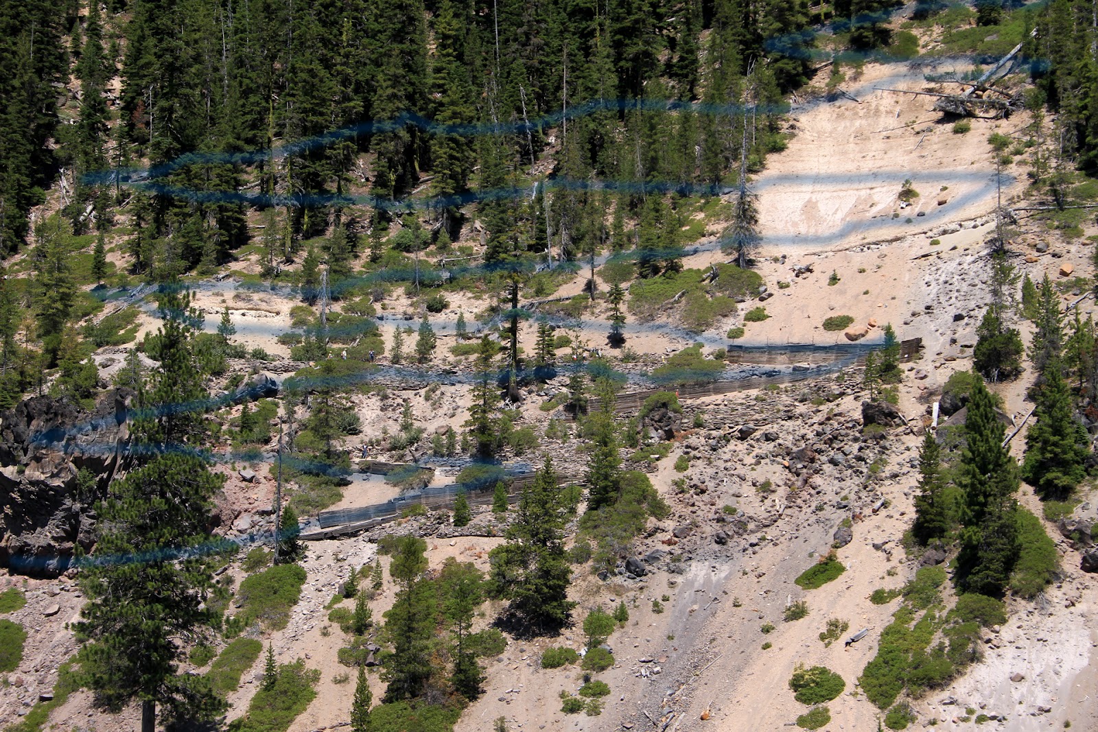
The picture above is from the Cleetwood Cove trail. It is the only access to the lake shore unless you get permission to throw yourself off one of the cliffs. People take the trail to swim in the lake, although they usually stay in briefly and get out pretty quickly. The lake water is cold. In the cove it may reach into the 60's, but if you swim out a few feet the rock ledge below you drops a couple of hundred feet. The bluer the water the colder.
The trail is one mile long and during the descent you lose 700 feet in elevation. That means switch backs. I added the blue lines to make it easier to find the trail in the picture.

Hiking down took us about twenty minutes. Hiking up took us one hour and it is as strenuous as the booklet describes. Once we got down we boarded a small boat for a two hour tour. No three hour tours and the lake is contained inside the crater so a repeat of Gilligan's Island is not possible.
The small rocks that make up the substance around the trail are yellowish in color, indicating they've been exposed to sulfur. Scientists flew as DSRV (Deep Sea Rescue Vehicle) into Crater Lake by helicopter and explored. Towards the middle of the lake, 1400 feet below the surface, there are thermal vents indicating that the magma chamber below is still active and will likely erupt at some point. Before that happens there are hundreds, if not thousands of small earthquakes that serve as a warning, usually over a period of several weeks or months.
Over the geologic lifetime of the crater there were multiple volcanoes. Frequently the eruptions were violent and all the rock and lava thrown out and upwards eventually collapsed down. In some cases erosion removed most of the remnants of their existence. In others the rock's mineral content permitted much slower erosion and created unique formations. One of them is nicknamed the Phantom Ship. If you use your imagination when looking at the picture below you might see it.

This is what is left of a crater wall and it sits on a rock ledge which drops off more than one thousand feet. Right near this rock formation you can stand up. Move about 5 feet way from it and you are jumping off a thousand foot cliff.
There are fish in the lake, placed there by the National Park Service in the belief that no one would come to see it without another reason. Not that many people fish, so the ones that do catch very, very large trout. In order to fish you must use the Cleetwood Cover trail and then find a spot along the bank somewhere. No boats other than the ones the National Park Service operates, are permitted. Wading into the lake isn't advised.
The tree trunk you see below is called "the old man." It is over 100 years old and it floats slowly around the lake. It is always in a vertical position. Most logs float horizontally. This one is so stable that in the past people climb on top of it and pose for pictures. It isn't permitted any longer. It extends downwards about 60 feet.


The picture above is from the Cleetwood Cove trail. It is the only access to the lake shore unless you get permission to throw yourself off one of the cliffs. People take the trail to swim in the lake, although they usually stay in briefly and get out pretty quickly. The lake water is cold. In the cove it may reach into the 60's, but if you swim out a few feet the rock ledge below you drops a couple of hundred feet. The bluer the water the colder.
The trail is one mile long and during the descent you lose 700 feet in elevation. That means switch backs. I added the blue lines to make it easier to find the trail in the picture.
Hiking down took us about twenty minutes. Hiking up took us one hour and it is as strenuous as the booklet describes. Once we got down we boarded a small boat for a two hour tour. No three hour tours and the lake is contained inside the crater so a repeat of Gilligan's Island is not possible.
The small rocks that make up the substance around the trail are yellowish in color, indicating they've been exposed to sulfur. Scientists flew as DSRV (Deep Sea Rescue Vehicle) into Crater Lake by helicopter and explored. Towards the middle of the lake, 1400 feet below the surface, there are thermal vents indicating that the magma chamber below is still active and will likely erupt at some point. Before that happens there are hundreds, if not thousands of small earthquakes that serve as a warning, usually over a period of several weeks or months.
Over the geologic lifetime of the crater there were multiple volcanoes. Frequently the eruptions were violent and all the rock and lava thrown out and upwards eventually collapsed down. In some cases erosion removed most of the remnants of their existence. In others the rock's mineral content permitted much slower erosion and created unique formations. One of them is nicknamed the Phantom Ship. If you use your imagination when looking at the picture below you might see it.

This is what is left of a crater wall and it sits on a rock ledge which drops off more than one thousand feet. Right near this rock formation you can stand up. Move about 5 feet way from it and you are jumping off a thousand foot cliff.
There are fish in the lake, placed there by the National Park Service in the belief that no one would come to see it without another reason. Not that many people fish, so the ones that do catch very, very large trout. In order to fish you must use the Cleetwood Cover trail and then find a spot along the bank somewhere. No boats other than the ones the National Park Service operates, are permitted. Wading into the lake isn't advised.
The tree trunk you see below is called "the old man." It is over 100 years old and it floats slowly around the lake. It is always in a vertical position. Most logs float horizontally. This one is so stable that in the past people climb on top of it and pose for pictures. It isn't permitted any longer. It extends downwards about 60 feet.

While much of the snow eventually melts during the summer there are patches that never leave the park. Snow stops in May or June and resumes in October. In August, the melting snow creates waterfalls, like Aida Falls. This run off adds about 52 million gallons of water to the lake each summer. However, the lake has a maximum level it will not exceed. 250 feet below one of the cliffs, underwater, the rock is very porous. Water seeps through it into surrounding ground water. There are brief periods of time when the water level of the lake can get high, but it eventually returns to about the same height you see in all of the pictures.

Subscribe to:
Comments (Atom)